McKee Neighbourhood Plan (Opinion)
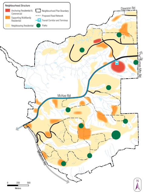
Image: The McKee Neighbourhood Plan (NP) area on Sumas Mountain, mainly consisting of residential sprawl. Source: City of Abbotsford.
About The McKee Neighbourhood Plan
Inspired by nostalgic urban planning characteristics, the City of Abbotsford is preparing a neighbourhood plan for McKee Peak on Sumas Mountain, a low-density, sprawling subdivision through nature-sensitive areas on the traditional and unceded territory of Sumas First Nation.
With a vision of 19,000 to 28,000 residents living within the proposed McKee neighbourhood, the plan forecasts 6,600 to 9,600 units over 769 hectares.
The current population within the boundary is about 4,600 people, mainly within the Auguston and Highlands neighbourhoods, housed within 1,193 dwelling units, including secondary units. Existing public school students within the plan area are 685, with a new projection of 3,070 to 4,210.

Image Source: Fraser Valley Conservancy video essay, "Why the FVC can not support the McKee Neighbourhood Plan" and "Why you should Speak for the Peak."
McKee and The Official Community Plan's Big Ideas
Our municipality's official community plan (OCP) objective is for a compact city with a guiding principle of "we build up much more than we build out."
The City's McKee proposal document reads: "...the McKee [Neighbourhood Plan] is consistent with the overall urban structure and growth objectives, supports the policy framework and helps realize the [OCP's] 7 Big Ideas."
The OCP's seven big ideas are:
- Create a city centre
- Establish distinct and complete neighbourhoods
- Make walking, biking and transit delightful
- Make places for people
- Improve natural and built systems
- Enhance agricultural integrity
- Make the plan work
The McKee Neighbourhood Plan (NP) achieves the opposite of the OCP with a low-density nostalgic cul-de-sac sprawl design that is not walkable and prioritizes car use.
Although the proposed McKee village centre will allow up to six stories of mixed-use commercial and residential, most of the land use plan consists of detached, sprawling, non-connected subdivisions.

Whistler's Car-Free Village Centre. Source: Tourism Whistler
Car-free squares and public plazas ought to be included in the village plan. In subsequent versions of the neighbourhood vision, the City adjusted a commercial street designation to prioritize cars further.
The project has no transportation mode shift or walkability goals. The plan needs to outline measurable goals to transition a percentage of residents to active transportation and transit. Residents should be able to walk to essential daily amenities within 15 minutes.
McKee Road will induce traffic and encroach on people-oriented spaces, extending into the plan's central area with four lanes designed for high speeds. No All-ages-and-abilities active transportation infrastructure connects schools, neighbourhoods, and other municipality areas. Identified trail networks do not substitute for AAA infrastructure. Consideration for downstream traffic in different areas of the municipality, including the urban centre, needs to be addressed.
The plan identifies locations for two elementary and one high school site required through provincial legislation, a supermarket and a transit hub. There is no consideration for non-market real estate uses, like daycare, community gardens, a walk-in clinic and co-op housing.
Attracting and inducing car traffic to the McKee neighbourhood from other areas is the (unintended) vision. Unlike the NP's conceptualized commercial units, there is no neighbourhood-scale expectation for a grocery store. For schools, the only transportation mode identified in the project is collector-and-arterial car roads. There must be a plan for all-ages-and-abilities active transportation and transit infrastructure for schools. The vision needs efficient and effective transportation components while reducing commuter friction with solutions like work-live units for entrepreneurs and professionals.
The Iceberg Effect
The McKee Neighbourhood Plan (NP) speaks to capital costs covered by developers but does not discuss ongoing operations, maintenance and replacement liabilities.
A City of Kelowna planner, James Moore, during a 2021 council presentation, described the associated costs of sprawl to be like an iceberg.
"When we talk about development cost charges and what we get from a new development paying for its own infrastructure up front, that may be beneficial for the first number of years. But, eventually, this kind of iceberg catches up to you, and that share of that pie, those up-front capital costs that are sitting above the water, get smaller and smaller and smaller the longer you go out and the more you have to operate and maintain.
The kind of distance that these places are from the central area of the City start to outweigh the revenue we get from them to maintain their systems, and they become a drain on the City in the long run.
Really, it's a gift for year one and an obligation for 200 years after that," Moore said.
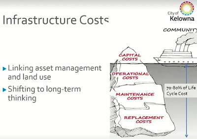
Image Credit: City of Kelowna.
Future development designation under an official community plan does not confer development rights in British Columbia.
In 2018 the City of Kelowna altered its Official Community Plan, closing areas for suburban development. Instead, the City focuses on infill, multi-family development, increased transit use and developing a more livable city with higher-density neighbourhoods.
Kelowna City Council affirmed its policy in 2021, rejecting a suburban subdivision development proposal for approximately 650 homes.
Brent Toderian, the City's urban planning consultant who assisted with Abbotsford Forward - a prequel to our current official community plan - and former City of Vancouver Chief Planner, often communicates publicly against suburban sprawl, like the McKee NP.
In a Winnipeg Free Press article published on October 21, 2022, Toderian said, "If you want to have a conversation about avoiding future municipal tax increases…suburban sprawl is an incredible drain on municipal finances, and thank goodness you've [Winnipeg] got the inner-city and infill development to subsidize it."
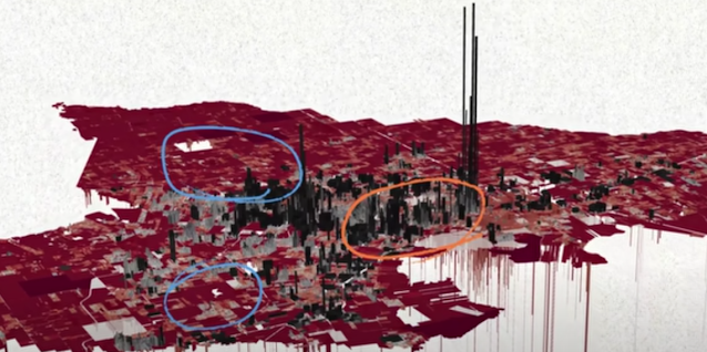
Image: The screenshot highlights revenue vs. expenses in Lafayette, Louisiana, calculated by Urban3. The grey areas are the lower-income tax revenue-positive neighbourhoods, subsidizing the wealthy suburban sprawl tax-revenue-negative red areas. Source: "Suburbia is Subsidized: Here's the Math," by Not Just Bikes, Published on YouTube - March 7, 2022.
What is the McKee NP expense return? Or the revenue per hectare?
The McKee NP document does not consider, outline or project revenue and expenses.
Municipalities are engaging with consulting companies like Urban3, which calculates the tax income vs costs of existing and planned urban projects, to help answer questions of development economics. Governments are discovering typical suburban development is subsidized by highly efficient and effective urban areas with multi-family development, re-affirming the iceberg effect highlighted by the City of Kelowna's planner, James Moore.
The McKee NP will have additional geotechnical and stormwater management costs beyond typical low-density sprawl.
The City of Abbotsford put Tradex up for tender to generate additional revenue citing in an October 2021 Abbotsford News article an estimated $1.9 billion in forecasted infrastructure costs over the next 25 years. What other ongoing operations, maintenance and replacement costs will the McKee Plan create for taxpayers?
According to the McKee NP, the median household income within the plan area is $122,400. $72,500 is the median household income for the entire City, a difference of $49,900. Will lower-income households in productive urban regions of the City subsidize the McKee NP through inequality of higher taxes, increased traffic, fewer amenities and lower transit frequency?
Transportation and The Missing Middle
Like McKee Neighbourhood Plan (NP), suburban sprawl is not a housing policy. It is an industrial approach to create economic opportunity for select developers and land owners, sell cars and finance road contractors at a high cost.
Transportation is about an entire multi-modal system working together. A development like the McKee plan locks people in place, economically and physically, with one mode option: cars. Sprawl adds traffic pressure on our City's urban area, ideally suited for high-frequency transit, walking, mobility-aid scootering, cycling, car-share and car-light transportation modes. With up to 28,000 residents projected for McKee, it will make transportation in the urban area less efficient and effective.
Transit
Image: There is no transit in one of the highest-density areas of Abbotsford, Garibaldi Drive and Gladwin Road. Source: Google Earth.
Despite a new transit yard opening in Abbotsford, first-person accounts of our transit system published on social media and reported by journalists are deplorable.
The McKee NP will worsen transit. Sprawl spreads out bus assets thinly, increasing transit stop time intervals and lessening market appeal. One of the highest-density neighbourhoods of Abbotsford in the urban centre has no transit, yet buses service suburban sprawl on Sumas Mountain.
The City wants residents to use transit while its administrative employees and elected officials enjoy a private fleet of vehicles. Elected officials and senior municipal staff need to provide proof of concept of our transit service. How will spreading out bus assets to low-density areas further improve the situation?
Health
The McKee NP is detrimental to mental and physical health.
Cars, including electric, are not a solution for urban mobility, which urban sprawl like the McKee Plan promotes through more cars and driving further: pollution from wheels and brakes, natural resources extraction, unhealthy lifestyles and collisions. Fewer cars and less driving have to be the solution for urban mobility.
Being trapped in a suburban neighbourhood with a car-dependent cul-de-sac design and insufficient cut-throughs will affect a child's growth and independence. Only 28% of children in Canada walk or cycle to school compared to 58% about 40 years ago. Since the 1970s in Canada, we have moved away from building walkable, compact, amenity-rich neighbourhoods.

Image: Example of the proposed McKee NP cul-de-sac land use with unconnected streets (yellow area) from the village (highlighted in teal) separated by a major road. Source: Page 16, Final Council Presentation - June 13, 2022. Source: City of Abbotsford.
Overall, traffic fatalities in The United States and Canada have dropped by putting everyone in a car. However, pedestrian fatalities and significant conflicts have increased in the last few decades through increased car traffic, larger vehicles, distracted driving and higher vehicle speeds. Unsafe roads lead to parents driving their children more, further enhancing the problem.

Image: The City of Abbotsford's demonstration of creating walkable and transit-friendly neighbourhoods through its Abbotsford Forward Twitter handle on December 16, 2014.
Noise pollution should be considered in urban and transportation planning. Single occupancy car traffic is one of the largest sources of pollution, including noise pollution. Examples include adverse effects on mental health, exacerbating stress levels, sleep disturbances, and negative impacts on cardiovascular and metabolic systems. The City's Transportation and Transit Master Plan references these harmful effects.
Missing Middle
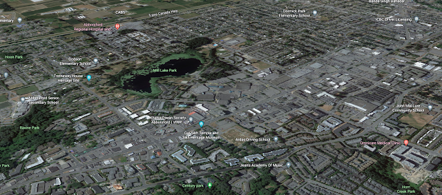
Image: Much of the Noo-kó-kum (Mill Lake) and Clearbrook neighbourhoods in the urban centre pictured are low-density sprawl with single-family housing and flat surface parking lots, ideal for missing middle infill with walkability appeal. Source: Google Maps.
Instead of building sprawl to accommodate growth, we need to re-rejuvenate and infill decades-old light-density neighbourhoods in the urban centre, like the Clearbrook and Noo-kó-kum (Mill Lake) neighbourhoods.

Missing middle concepts by Lanefab of Vancouver
The missing middle is a transformative concept of housing types mixed with detached homes and small to large multi-family buildings. Many infill designs allow for small rental or strata multi-plexes on individual residential lots, saving land assembly time and giving neighbourhoods more character. Smaller apartment complexes on individual lots create more competition among rental buildings and are less appealing to real estate investment trusts (REIT), encouraging more local ownership.
Infilling our urban centre will allow Abbotsford to be financially resilient while creating healthy, safer, amenity-rich neighbourhoods.
Abbotsford Advantage
We are in a position of leverage to ask for more from developers, with investments in amenities and transportation infrastructure for transit and active transportation.
Abbotsford is the largest municipality by population in British Columbia outside of Metro Vancouver, with a nearby trading area of almost three million people. The City is a transportation centre with VIA Rail, a commercial airport, an interurban bus network, a national highway and a 24-hour U.S. - Canada border crossing, the main port-of-entry on the north-south route between California and Alaska.
Since 2017, the average building-permit approval wait times for multi-family projects increased from seven to 20 weeks in 2022. During the same period, single-family home permit approvals have increased to 16 weeks from 6.4 weeks. Although building permit delays are a problem, it indicates demand.
Building-permit demand and a strategic location provide the City leverage to establish higher expectations among developers.
Lack of Support and Consultation
Natural Habitats
Although a strong theme of the plan is to work with the land, the proposal does not have Fraser Valley Conservancy's (FVC) endorsement.
Involved in the planning process for approximately five years, the degrading of the initial landscape-level vision for the natural areas over subsequent versions is a concern of FVC. The FVC has cited various issues, most notably that the plan as proposed is not sustainable and does not meet the needs of nature.
The FVC is mainly concerned about the loss of intact forests, the hydrological changes that will permanently alter the natural areas and contribute to downstream flooding, plus the impact the habitat loss will have on wildlife, including many species at risk.
The McKee Neighbourhood Plan (NP) includes seven habitat hubs; however, only one, a parcel of land owned by FVC known as Three Creeks, is a truly protected habitat, according to FVC. The other six habitats lack guaranteed protection from development or trail networks. The proposed McKee NP neighbourhood centre would be situated within one of the protected habitats. Wildlife corridors connecting the habitats need to be suitably sized and connected.
Tourism
Although McKee Peak, with an extensive trail network, is considered a significant natural resident and visitor attraction, according to a letter from the Tourism Abbotsford Society (TAS) addressed to the City of Abbotsford (COA) dated May 27, 2022, the COA did not adequately consult TAS.
"While we are thrilled to see that recreational tourism is recognized in the [McKee Neighbourhood] plan, we are disappointed Tourism Abbotsford hasn't been included in stakeholder engagement sessions…."
A lack of tourism and recreation industry consultation in 2021 resulted in Tradex, a popular cost-neutral community asset managed by TAS, being put up for tender by the COA based on incomplete information.
Last spring, the President of Abbotsford Trail Development Society and Fraser Valley Mountain Bike Association vice-president, Yoshia Burton, told Fraser Valley Current's Editor, Tyler Olsen, "It's the dirt that makes McKee Peak world-class." In the article "can one of Canada's best trail networks survive development," Burton further explained:
"There are lots of beloved mountain biking trails around North America: heavily used tracks in Colorado, Whistler, and beyond that grace magazine covers, glossy advertisements, and tourism brochures. The trails on McKee Peak, above Whatcom Road in Abbotsford, are better. They are more accessible and more fun, thanks to the moldable and varied terrain they're built on and their close proximity to the thousands that use them."
Residents
The City must still convince residents of the McKee Neighbourhood Plan (NP).
In collected surveys from May 13 - 30, 63% of respondents said no, with the remaining responding 23% somewhat and 14% yes.
Findings from three in-person open houses on May 17, 18 and 19 with 170 attendees resulted in 42% no, 31% somewhat, and 27% yes.
Accumulative findings of 545 total respondents found 58% said no, with 25% somewhat and 17% yes.
In 2019, the City's methodology of collecting responses from online surveys came into question. The Abbotsford News published a story about the issue, "Abbotsford wasting time and money on 'invalid' surveys, UFV math prof says."
There were landowner meetings to discuss the infrastructure and proposed land uses. The number of sessions and the outcomes of these discussions compared to residents and other critical stakeholders are unavailable. The City of Abbotsford declined my request for a list of properties within the subject area.
There were landowner meetings to discuss the infrastructure and proposed land uses. The number of sessions and the outcomes of these discussions compared to residents and other critical stakeholders are unavailable. The City of Abbotsford declined my request for a list of properties within the subject area.
Heat and Rain
Trees can impact heat and rain. In the summer of 2021, almost 80 Fraser Valley residents died during the heat dome. According to a Fraser Valley Current (FVC) story, summer rain in Abbotsford is much rarer now, declining over the past two decades. Bill Hardy, the president of the Canadian Nursery Landscape Association, told FVC that lost green spaces in the Lower Mainland likely have influenced our weather, including rainfall.
Much of the proposed McKee Neighbourhood Plan (NP) greenspace comprises Legeview Golf Course and steep-grade terrain. This point is highlighted during March 6, 2023, McKee NP public hearing at the 20:13:48 time mark.
First Nations
There are no First Nation Reserves within the McKee NP subject area. However, the area is on the traditional and unceded territory of the Sumas First Nation, with cultural and historically significant sites. Its original reserve was more extensive, according to a CBC article published in 2020. Concerning historical grievances and the Trans-Mountain pipeline on Sumas Mountain, the CBC article states, "...possible new claims represent a hidden liability potentially in the hundreds of millions of dollars..."
According to The Abbotsford News, there was some consultation with First Nations; however, First Nations support and a 'win-win' outcome for the McKee NP appears to be lacking based on presentations given and documents submitted during the March 6, 2023, McKee NP public hearing.
Truck Parking and Traffic Congestion at Whatcom Road Exit

An aerial overview of the proposed Whatcom Road transit exchange at Highway 1 Exit 95, a site currently used as commercial truck stop parking
Truck parking in Abbotsford is a significant issue. Further development on Sumas Mountain envisions a transit exchange, reducing truck and carpooling parking at Whatcom Road Highway 1 Exit 95, which is congested. Low-density sprawl on Sumas Mountain will not induce a transportation mode shift to attract choice transit passengers who have alternative options. With low-frequency intervals, transit service on the mountain will have a limited market appeal. When truck parking was established on Sumas First Nations land near Whatcom Exit in 2017, the previous Mayor of Abbotsford said to The Abbotsford News, "We have more traffic than we can handle on Whatcom."
Moving Forward

Overlooking Noo-kó-kum (Mill Lake) at Centennial Park, also known as Mill Lake Park.
Copyright Ross Brown, April 2022
Initial upfront development fees derived from the McKee Neighbourhood Plan (NP) are not income. It exchanges an ecological, tourism and historical asset for dollars, with the associated long-term low-tax vs costs liability.
Proceeding further with the McKee NP without a financial analysis, measuring tax revenue per hectare vs ongoing expenses would be irresponsible. Other considerations include higher economic input costs, lost economic development through less desirable urban areas, tourism assets and transportation systems with no quantifiable transportation mode-shift goals, undesirable health outcomes, and environmental degradation.
Our newly elected City Council has a choice to be bold. Protect the remaining undeveloped areas of Sumas Mountain into a legacy destination park in collaboration with Sumas First Nation for our residents, visitors, history and environment, like previous councils did to establish, protect and expand Centennial Park, also known as Mill Lake Park. Perpetuate social, natural and economic benefits. The financial cost would be offset through non-Abbotsford resident park pass fees, certified guide fees, pay car parking, ancillary revenue and a 1% tourism product development hotel tax, plus indirect tourism ancillary revenue and economic benefits.
Further Reading
McKee Neighbourhood Plan Posts
= = =
Keywords: Abbotsford, Sumas, Mountain, McKee, peak, neighbourhood, plan, proposal, project, sprawl, suburban, nature, environment, infrastructure, deficit, higher, increased, tax, taxes, expenses, cost, revenue